Late last night, in Korea, I was reading the Twitter messages and discussion about a possible looping of Hurricane Matthew. Now, tonight, I see that the NWS is beginning to forecast such a loop.
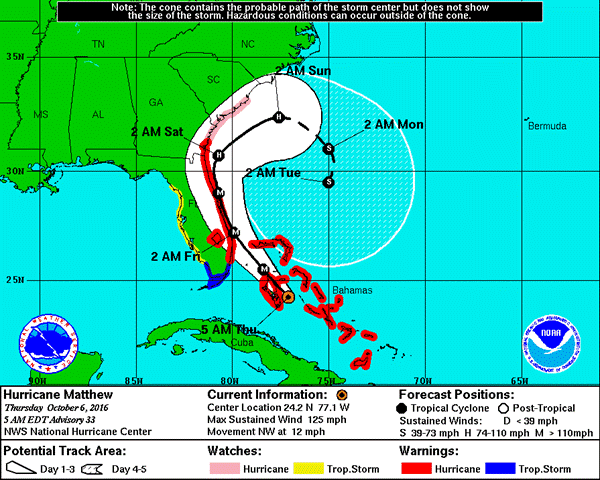
This looping of a storm presents a scary situation for disaster relief planners and workers in the affected areas. Where the storm may pass this weekend, the storm may return two or three days later. It is unusual situations like this one that we must always be ready for. My fear is that the storm will pass and people will begin to come out of their protected places to begin clean up when the storm returns. We must continually check on the weather, especially when we know that there is a storm approaching.
I am not a weather forecaster, but I have been watching forecasters for years. Forecasting is hard work, but it can be done. We have some expectation that the storm will go as projected. We also have experience to know that at the last minute the storm can change direction. In my mind, the people in SC and Georgia are still at threat because they are under the white cone. I also have seen the forecast change with every new posting of the latest track.
Things change. Winds change. Water temperatures change. Systems change. What is predicted to hit in a certain place one day, often changes as the forecasts develop. It is important , therefore that we monitor closely a trusted local weather media outline and/or the National Weather Service office closest to you at Weather.Gov. It is never too early to be prepared for disaster.
—–
Graphic from The National Hurricane Center.