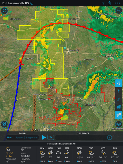
On stormy days like today, I keep my eyes on the radar information provided by the Storm App by Weather Underground. The Storm app has become my go to radar on my iPhone and iPad. From this app, I can see the radar picture as well as graphics and other information that become important to me as I watch the weather. Reading the radar on the storm app is also very simple to understand. I took this screenshot today to demonstrate the basic weather graphics information that are available on the app.
The definitions of the weather information are taken from the National Weather Service Glossary. For more detailed information, please see that site for more information.
1. The Red boundary marker is a “Low”. A Low is defined as “A region of low pressure, marked as “L” on a weather map. A low center is usually accompanied by precipitation, extensive cloudiness, and moderate winds.”
2. The Blue boundary marker is a “High”. The National Weather Service defines a High as “a region of high pressure.”
3. The brown boundary is a new boundary to me and it is called a “Dry Line” or “A boundary separating moist and dry air masses, and an important factor in severe weather frequency in the Great Plains.”
4. The yellow boxes are important to pay attention too. They represent a Severe Thunderstorm Watch, which is “issued by the National Weather Service when conditions are favorable for the development of severe thunderstorms in and close to the watch area.”
5. If you look closely you will see the shaded in yellow boxes, they represent a Severe Thunderstorm Warning. “This is issued when either a severe thunderstorm is indicated by the WSR-88D radar or a spotter reports a thunderstorm producing hail one inch or larger in diameter and/or winds equal or exceed 58 miles an hour; therefore, people in the affected area should seek safe shelter immediately.”
6. The red boxes represent a Tornado Watch. A Tornado Watch is “issued by the National Weather Service when conditions are favorable for the development of tornadoes in and close to the watch area.”
7. Although not pictured, a Shaded Red Box represents a Tornado Warning. A Tornado Warning “is issued when a tornado is indicated by the WSR-88D radar or sighted by spotters; therefore, people in the affected area should seek safe shelter immediately.”
Understanding the information on these graphics can help you understand the weather as it is approaching your home or any outside activities that you may have. Understanding potentially hazardous weather can improve your response time to dangerous weather greatly. But, as a reminder, always stay tuned to your “NOAA Weather Radio”, “All Hazards Radio”, or local media during inclement weather.
—–
Screenshot image taken at 1920CDT on 9MAY16.
This post is a part of my participation in the Weather Ready Ambassador Program. For more information, see the National Weather Service Weather Ready Nation Website.